
– Col. Ajay Kumar (Retd)
Public remarks by Indo-Tibetan Border Police (ITBP) Director General Shatrujeet Kapur about continuing face-offs along the Line of Actual Control (LAC) in Arunachal Pradesh prompted political argument and extensive media commentary. The immediate reaction often treated the existence of a face-off as evidence of a sudden military setback. That conclusion does not follow from the statement alone.
The remarks point to two operational realities on the India-China frontier:
- First, low-intensity friction in Arunachal Pradesh is a recurring feature of a border where the two countries have not agreed on a mutually accepted line. Patrols may encounter one another because their respective territorial perceptions overlap.
- Second, India’s posture has changed as roads, forward facilities, surveillance and specialized personnel have improved. The reference to ITBP’s Shaurya personnel reflects an effort to strengthen the response to close-range encounters in difficult high-altitude conditions.
The border situation is best assessed by separating four questions: why the LAC remains disputed, where geography creates recurring contact, how troops are expected to behave during a face-off, and what changes in infrastructure and force posture mean for the balance on the ground.
The Legal and Historical Framework of Border Perceptions
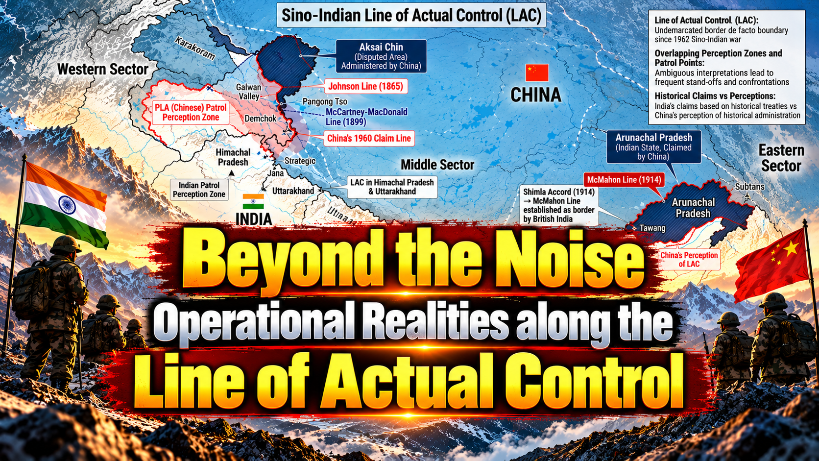
The central problem is the absence of a mutually accepted, legally demarcated boundary between India and China along the entire frontier. Commonly described as extending over 3,400 kilometres, the disputed boundary spans three sectors: the Western Sector (Ladakh), the Middle Sector (Himachal Pradesh and Uttarakhand), and the Eastern Sector (Sikkim and Arunachal Pradesh).
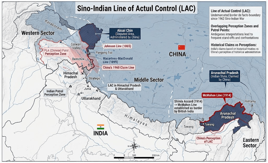
The dispute is rooted partly in competing historical maps and colonial-era boundary proposals that neither side has accepted in their entirety.
- Johnson Line (1865): Placed Aksai Chin within the territory associated with Jammu and Kashmir, broadly reflecting India’s historical position in the Western Sector.
- Macartney–MacDonald Line (1899): Proposed a different alignment, placing much of Aksai Chin on the Chinese side.
- Ardagh Line (1897): Advanced a more northerly boundary to strengthen the strategic defence of British India.
- McMahon Line (1914): Drawn during the Shimla process, it forms the basis of India’s boundary claim in the Eastern Sector, including present-day Arunachal Pradesh; China does not accept it.
Without a mutually agreed alignment along the frontier, Indian and Chinese forces continue to operate on the basis of their respective perceptions of the Line of Actual Control (LAC). An Indian Army or ITBP patrol may therefore encounter a People’s Liberation Army (PLA) patrol in an area that both sides claim.
For field commanders, this ambiguity is a persistent operational challenge. Patrol limits, routes, decision points and escalation procedures must be clearly defined, while every encounter must be documented with precise location, timing and details of both sides’ actions. Consistent records help identify emerging patterns, distinguish isolated encounters from sustained changes on the ground, and provide commanders and policymakers with the evidence needed to determine whether an incident can be resolved locally or requires higher-level intervention.
Spatial Analysis: Key Operational Flashpoints in Arunachal Pradesh
The terrain also affects the quality of information available to decision-makers. A patrol may have a limited view of the surrounding area, while weather can interrupt radio contact or prevent reinforcement. A report from one location may therefore provide only part of the picture. Commanders need to combine patrol observations with imagery, local intelligence and reports from neighbouring posts before deciding whether a movement represents a routine approach or a deliberate attempt to alter conditions. This is particularly important when public commentary begins before the operational picture is complete.
The Eastern Sector combines high ridgelines, forested slopes, narrow valleys and deep river gorges. These conditions make continuous physical presence along every kilometre impractical. Patrols must work within limits set by weather, altitude, visibility, access routes and the time required to move through difficult ground. Better roads and forward infrastructure on both sides have increased the ability to reach remote areas.

Primary Sectors of Friction
Tawang Sector: Yangtze and Holy Water Post
Tawang has military and political significance because of its location near routes into the Assam plains and its position within the eastern Himalayan region. The Tawang Monastery also gives the area religious importance.

- Yangtze Plateau lies at an altitude of more than 14,000 feet and offers observation over nearby approaches. Its elevation and terrain make it important for monitoring movement, but they also make operations physically demanding. In December 2022, Indian and Chinese troops clashed in the Yangtze area. India said its troops had firmly confronted the PLA attempt to alter the status quo.
- Holy Water Post, near Bum La, illustrates the way a small local feature can become a recurring point of friction. Access to a waterfall and the ridge lines around it can influence patrol movement and observation.
Taksing Sector: Upper Subansiri
Taksing, in Upper Subansiri district, is among the more remote parts of the eastern frontier. Rugged terrain and limited population have historically made regular access difficult. Where patrols once reached certain areas only occasionally, improved roads and support facilities allow Indian teams to visit them more frequently. Asaphila, near Taksing, has been cited as an area of friction.
Siang and Tuting Sectors
In this area, the Yarlung Tsangpo flows into India and becomes the Siang, later joining the Brahmaputra system. Near the Great Bend, the river turns around the Namcha Barwa massif and cuts through exceptionally steep terrain. The river system creates a cross-border security issue because decisions taken upstream can affect communities downstream.
- Hydrological risk is part of the strategic discussion around Chinese plans for a major hydropower project near the Great Bend. The source text cites a proposed capacity of 60,000 megawatts. The scale and operating details of such a project should be verified against official and technical information before being treated as settled.
- India’s proposed Upper Siang multipurpose storage project is discussed as a means of improving water management and providing a buffer against sudden changes in flow. Its design, environmental impact, local consent and resettlement implications require careful examination. Security planning should account for hydrological data, warning systems, communication between agencies and downstream preparedness.
Kibithu and the Wacha-Damai Sector
Kibithu, in Anjaw district, is among India’s easternmost forward locations. Across the frontier lies the PLA’s Wacha-Damai area. The sector’s remoteness and its position on the eastern edge of the frontier make access, communications and logistics important to sustained deployment. The source document refers to Corps Commander-level talks in September 2026.
Operational Mechanics: Face-Offs, Protocols and Tactical Evolution
The distinction between an encounter and a crisis is useful for policy as well as field command. An encounter can be managed through local procedures if both sides maintain discipline and communicate. A crisis develops when violence causes casualties, reinforcements are moved in a threatening manner, access is blocked for a sustained period or political leaders begin to treat the incident as a test of national resolve. Early reporting and established communication channels give both sides a chance to prevent a local event from becoming a wider confrontation.

A face-off is a direct encounter between patrols whose territorial instructions overlap. It can involve verbal exchanges, the display of signs or banners, photography and an effort by each side to persuade the other to withdraw.
Bilateral Protocols: The 1996 and 2005 Agreements
India and China have signed agreements intended to reduce the risk of accidental escalation along the LAC, including the 1996 Agreement on Confidence-Building Measures in the Military Field and the 2005 protocol on implementing those measures.
- The agreements call on both sides to exercise restraint when troops encounter one another. The purpose is to prevent a local patrol dispute from turning into a wider confrontation through hurried decisions or unnecessary force.
- The source document states that patrols within two kilometres of the LAC are prohibited from carrying firearms or explosives. This should not be presented as a universal rule without checking the exact wording and scope of the relevant agreements and subsequent arrangements.
During a face-off, patrols may halt, issue verbal warnings, display banners in relevant languages and record the encounter. These actions create a record of what happened and communicate each side’s position. The presence of cameras can also discourage later disputes about the sequence of events, though footage must be interpreted in context.
Tactical Innovation: ITBP’s Shaurya Personnel and Quick Reaction Teams
The reference to specialized Shaurya personnel points to the need for border forces to be trained for close contact in high-altitude conditions. The ITBP was raised as a force with mountain-operating expertise and was assigned responsibility for guarding the China frontier in 2004.
+———————————————————————————–+
Specialized High-Altitude Quick Reaction Teams
Quick Reaction Teams are intended to respond rapidly when a local incident requires additional personnel. In high-altitude terrain, the response has to account for reduced physical performance, limited road access, weather and the time required to move reinforcements.
Behavioural Analysis and Counter-Tactics
Video and written reports from patrol encounters can help commanders understand how an incident developed, whether instructions were followed and which actions increased or reduced tension. Intelligence analysis may examine recurring patterns in patrol behaviour and the tactics used by local commanders. The source document refers to agencies and units associated with intelligence analysis, including the Special Frontier Force and R&AW.
Drone Surveillance and Counter-Drone Measures
Small unmanned aerial vehicles can help monitor approaches, identify movement and provide a view of terrain that is difficult to observe from a post. Their utility depends on altitude, wind, cold, battery performance, line of sight and the ability to transmit imagery securely.
Political Framing and the Limits of Headlines
The statement by the DG that face-offs continue along the LAC must be assessed in its operational context, and not in isolation. Such encounters may reflect the physical assertion of competing territorial claims along an unresolved frontier, rather than a sudden deterioration in the security situation. The statement alone, therefore, establishes neither a loss of territory nor a failure of India’s border posture. But neither does the recurring nature of these encounters make them inconsequential. Their significance depends on the location, circumstances, outcome and any change they produce in the ground situation.
A face-off demonstrates the presence of Indian forces and their willingness to contest the opposing patrol’s movement; it does not, by itself, establish that India has prevailed in every encounter or that the status quo remains unchanged. Those judgments require evidence of what happened on the ground, including whether patrol access was maintained, whether either side altered its position, and whether the incident had lasting operational consequences.
The strategic issue is thus not whether face-offs occur, but what they reveal about each side’s ability to maintain its presence, defend its claims and prevent local confrontations from changing the situation to its disadvantage. Headlines may reduce these events to a contest between success and failure, but a serious assessment must distinguish between a patrol encounter, a sustained restriction on access and a material change in ground realities. The facts on the ground, not the political interpretation of a short statement, must determine the judgment.
China’s Strategic Calculus and Grey-Zone Activity
Much of the China’s approach along the LAC is better understood as an effort to strengthen territorial claims and gradually shape conditions on the ground without crossing the threshold of open conflict. This is the essence of grey-zone activity: applying sustained pressure through patrols, infrastructure, administrative decisions and civilian presence, while keeping each individual action below the threshold to provoke a major military response.
Chinese strategic thinking also places considerable importance on national prestige and the avoidance of visible setbacks. The concept of mianzi, or “face”, can offer one perspective on Beijing’s public messaging and its sensitivity to perceived humiliation.
The so-called “Thousand Grains of Sand” approach captures another dimension of this strategy: the cumulative effect of numerous activities that, taken individually, may appear routine but together can establish a more persistent presence. Patrols, border settlements, supporting infrastructure and civilian activity can all contribute to strengthening a territorial claim over time. China’s development of border villages and associated infrastructure in some frontier areas illustrates the importance it attaches to maintaining a visible and enduring presence.
Other measures, including the renaming of geographical features, the development of infrastructure with potential civilian and military uses, and civilian herding in sensitive areas, can also serve to reinforce claims. Their significance lies not necessarily in any single incident, but in the possibility that repeated actions gradually alter the practical realities of a disputed frontier.
For India, the challenge is to recognise such patterns early and respond proportionately through diplomatic engagement, effective administration, infrastructure development and appropriate security deployments. Each reported incident must still be verified; strategic vigilance should not come at the cost of factual accuracy.
Strategic Outlook: India’s Modernization and Multi-Domain Posture
India’s response to the LAC challenge increasingly rests on three pillars: forward access, operational readiness and strategic leverage. The objective is to respond swiftly to PLA activity, sustain a presence in remote areas and prevent unilateral attempts to alter the ground situation.
Infrastructure and Forward Access
Roads, bridges, tunnels and communications infrastructure are strengthening India’s ability to reach forward areas, particularly in Arunachal Pradesh. Routes linked to the Trans-Arunachal Highway, together with improved logistics and forward airfields, enhance the movement of troops and supplies. Infrastructure is not merely developmental; it is a direct enabler of border security and operational resilience.
Operational Command and Coordination
The ITBP is responsible for border outposts and patrolling within its assigned mandate. In a crisis, effective coordination with the Indian Army becomes critical. The arrangements described in the source document provide for forward ITBP units to integrate under Army operational command during contingencies. Clear command structures and coordinated action are essential to ensure a timely, coherent response to emerging threats.
Economic and Diplomatic Leverage
India has made clear that normalisation of relations with China depends on maintaining peace and tranquillity along the border. Yet, deep economic links cannot be unwound overnight. India’s parallel efforts to diversify supply chains and strengthen strategic and defence partnerships across the Indo-Pacific reduce long-term vulnerabilities and widen its strategic options.
The larger objective is to combine military preparedness with diplomatic firmness and economic resilience. A credible posture along the LAC requires not only the ability to respond to immediate pressure, but also the capacity to sustain that response over time.
Conclusion
The continuing face-offs along the LAC should neither be dismissed as routine nor treated as automatic evidence of a security failure. They reflect an unresolved boundary dispute in which both sides seek to maintain their claims through patrols and physical presence. The real question is whether India can protect its positions, sustain access to contested areas and prevent local encounters from developing into a wider confrontation.India has strengthened its ability to operate along the frontier through better infrastructure, improved logistics and more capable border personnel. These investments provide a stronger basis for responding to Chinese activity, but their value ultimately depends on what India can sustain on the ground. Roads and surveillance systems matter only when they translate into reliable access, timely information and effective command decisions. Equally, restraint must not be confused with weakness, and firmness must not become a trigger for avoidable escalation.
The government’s performance should therefore be judged against clear operational facts: whether Indian patrols retain access to their established areas, whether attempts to alter the status quo are resisted, and whether the arrangements intended to prevent escalation are working. Public statements and isolated videos cannot answer these questions on their own. They require verified information and a consistent assessment of developments along the frontier.India must remain firm in defending its territorial claims while keeping communication channels open and diplomatic engagement active. That calls for sustained military preparedness, clear rules for troops on the ground and a realistic understanding of China’s actions and intentions. The objective is not to eliminate every encounter, an unrealistic expectation while the boundary remains unsettled. It is to ensure that India’s position is not weakened through persistent pressure, inadequate preparedness or errors in managing a crisis.
The measure of success is straightforward: India must be able to hold its ground, protect its interests and retain control over its response. That is the standard against which the situation along the LAC should be assessed, rather than the political interpretation of a single statement or face-off.



Leave a Reply